El Dorado County - Live Sierra Base
California, United States — 67 km
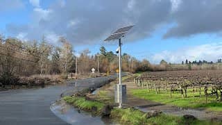
Diamond Springs - Green Valley Road Flooding Conditions
🇺🇸 California · United States — Altitude 460 m
This live camera watches Green Valley Road in Diamond Springs, El Dorado County, where seasonal flooding can affect travel. It is aimed at drivers who want to see how the road looks before heading out. Use it together with the local weather on this page to judge conditions.
Diamond Springs is a small community in the foothills of the Sierra Nevada, at roughly 460 metres above sea level. The area sits on the western slopes of the mountains, between the Central Valley and the high country around Lake Tahoe. Oak woodland, pine and seasonal creeks shape the landscape, and the town has a rural character with scattered homes and farms. Winters bring rain and, at higher elevations, snow, while summers are dry and warm.
The camera is categorised as a traffic view and is focused on road conditions, so it is most useful when rain has been falling or after storms, when low spots on the road may take water. Early mornings and the hours around the evening commute are when drivers tend to check it most. Because the image is a live stream, it shows what the road looks like at the moment, and conditions can change quickly as weather moves through.
Winters are the wet season, and roads in the foothills can become slick or flooded during heavy storms, so check the live view and forecast before driving after rain. Summers are hot and dry, with little road risk from water. For a wider picture of mountain conditions, you can look at nearby cameras such as El Dorado County Live Sierra Base, about 67 km away, or the Palisades Tahoe Alpine Summit view, about 70 km away. Drive carefully and follow official road advisories.
Source: CamStreamer
California, United States — 67 km

California, United States — 70 km

California, United States — 72 km

California, United States — 73 km

California, United States — 73 km
Florida, United States — 73 km

California, United States — 74 km

California, United States — 74 km
California, United States — 76 km
California, United States — 76 km
The current weather and the three-day forecast for Diamond Springs are shown in the live block on this page. Check it before driving, especially after rain.
The local time for Diamond Springs, which follows the Pacific time zone, is displayed on this page and updates live.
The camera watches Green Valley Road in Diamond Springs, El Dorado County, California, at about 38.72 north and 120.85 west, in the Sierra Nevada foothills.
Check during or just after rainfall, and early in the morning or around the evening commute, when the road is most used. The live view shows the current situation.
Partner links: we may earn a commission at no extra cost to you.