Niigata
Yamanashi, Japan — 24 km
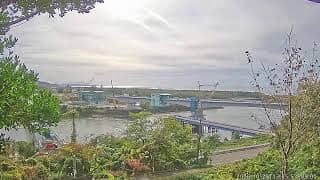
Nagaoka - LIVE JAPAN : Teradomari | 寺泊 大河津分水河口 (新潟県長岡市)
🇯🇵 Niigata · Japan — Altitude 5 m
This live stream looks out over the mouth of the Ōkawazu Bunsui river where it meets the Sea of Japan at Teradomari, in Nagaoka on the Niigata coast. It suits anyone who wants to see the current sea and river conditions on this stretch of coast before going there, or who simply likes watching a working coastline.
Teradomari sits on the flat, sandy shore of central Niigata Prefecture, facing the Sea of Japan. The Ōkawazu Bunsui is a flood-control diversion channel that carries surplus water from the Shinano River to the sea, so the river mouth is an engineered landscape as much as a natural one. The area is known for its fishing port and for the fresh seafood of the Japan Sea coast. The coast is open and exposed, with a strong sense of wind and weather.
The view is most informative when waves and river flow change, after rain upstream, during strong northwesterly winds, or in winter when the sea is rough. Depending on the angle, you may see the river meeting the surf, breakwaters, and the horizon. Early morning and late afternoon light tends to show the water texture best. Because the stream is live, what you see reflects conditions at this moment rather than any scheduled event.
Niigata's coast has cold, snowy winters and mild, humid summers, with the heaviest snow and rough seas usually arriving between December and February. Late spring and early autumn are the calmest seasons for coastal walks. Nagaoka is reached by Shinkansen and local rail from Niigata city, which is about 24 km away and is also covered by a nearby camera on this site, while the mountain resorts of Naeba and Madarao Kogen lie further inland.
Source: CamStreamer
Yamanashi, Japan — 24 km
Niigata, Japan — 77 km
Niigata, Japan — 95 km
Toyama, Japan — 99 km
Nagano, Japan — 101 km
Gunma, Japan — 101 km
Niigata, Japan — 102 km
Fukushima, Japan — 102 km
Gunma, Japan — 105 km
Niigata, Japan — 105 km
The current conditions and the three-day forecast are shown in the live weather block on this page, updated for Teradomari and Nagaoka. Check it before heading to the coast, since wind and waves can change quickly.
The local time for Nagaoka is shown in the clock block on this page, which follows Japan Standard Time. Use it to plan when to watch the camera for daylight or to time a visit.
The camera is at the Ōkawazu Bunsui river mouth in Teradomari, Nagaoka, on the Sea of Japan coast of Niigata Prefecture. The map on this page marks its position against the coastline.
Daylight hours give the clearest picture of the water. Winter storms and periods after heavy rain upstream often produce the most visible changes at the river mouth, though the view is live at all times.
Partner links: we may earn a commission at no extra cost to you.